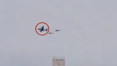
Video appears to show US plane and search and rescue helicopters over southern Iran
📖 Full Retelling
📚 Related People & Topics

Middle East
Transcontinental geopolitical region
The Middle East is a geopolitical region encompassing the Arabian Peninsula, Egypt, Iran, Iraq, the Levant, and Turkey. The term came into widespread usage by Western European nations in the early 20th century as a replacement of the term Near East (both were in contrast to the Far East). The term ...
Entity Intersection Graph
Connections for Middle East:
Mentioned Entities
Deep Analysis
Why It Matters
This incident matters because it suggests potential U.S. military or intelligence activity in Iranian airspace, which could escalate tensions between the two adversarial nations. It affects regional stability in the Middle East, particularly given ongoing proxy conflicts and nuclear negotiations. The presence of search and rescue helicopters specifically implies possible covert operations or personnel recovery missions, raising questions about U.S. objectives in Iran. This development is significant for international security analysts, regional governments, and diplomatic efforts aimed at de-escalation.
Context & Background
- The U.S. and Iran have had no formal diplomatic relations since 1980, following the Iranian Revolution and hostage crisis.
- Iran has frequently accused the U.S. of espionage and military incursions, including drone surveillance and cyber operations.
- The southern region of Iran is strategically important due to its proximity to the Strait of Hormuz, a critical oil shipping chokepoint.
- Previous incidents include the 2019 downing of a U.S. drone by Iran and the 2020 assassination of Iranian General Qasem Soleimani by the U.S.
- Search and rescue operations in hostile territory often indicate special forces missions or pilot recovery, recalling events like the 2011 capture of a U.S. RQ-170 drone.
What Happens Next
Iran will likely issue a formal protest or threat via diplomatic channels, possibly through intermediaries like Switzerland. The U.S. may either deny the incident or provide a limited explanation, citing intelligence gathering or routine operations. Regional tensions could increase, with Iran potentially bolstering air defenses or conducting retaliatory maneuvers. Monitoring of military communications and satellite imagery in the area will intensify among global intelligence agencies.
Frequently Asked Questions
U.S. aircraft might conduct surveillance to monitor Iran's nuclear activities, military movements, or support covert operations. Such flights, though risky, provide real-time intelligence not available via satellites. They may also be part of contingency plans for potential conflicts or hostage rescues.
Iran typically condemns violations as acts of aggression and sometimes displays captured equipment for propaganda. It may increase patrols or threaten retaliation, as seen after drone incursions. Responses can range from diplomatic complaints to military countermeasures, depending on the perceived threat.
Risks include escalation to direct conflict if aircraft are shot down or personnel captured, which could derail diplomatic talks. They also fuel Iranian narratives of U.S. hostility, hardening domestic opposition to engagement. Additionally, mishaps could lead to loss of life or sensitive technology falling into enemy hands.
Yes, such incidents may undermine trust and provide hardliners in Iran with evidence to resist compromises. They could stall talks by creating a hostile atmosphere or prompting retaliatory nuclear advancements. However, both sides have previously managed to separate operational tensions from diplomatic channels.
Videos should be verified for authenticity, as Iran has a history of disseminating edited or misleading footage for psychological impact. Geolocation and aircraft identification require expert analysis to confirm details. Independent verification via satellite data or radar tracking is often needed for conclusive assessment.