Tropical Cyclone Narelle to make landfall in far north Qld on Friday as category four storm, bringing 200km/h winds
📖 Full Retelling
<p>Massive storm tracking a path to Queensland coast, which intensified offshore Thursday morning to category five, fuelled by warm waters in Coral Sea</p><ul><li><p>Follow our <a href="https://www.theguardian.com/australia-news/live/2026/mar/19/australia-news-live-jim-chalmers-tax-inflation-budget-cost-of-living-war-fuel-crisis-shortage-inflation-cyclone-narelle-queensland-ntwnfb">Australia news live blog</a> for latest updates</p></li><l
Entity Intersection Graph
No entity connections available yet for this article.
Original Source
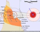
Tropical Cyclone Narelle to make landfall in far north Queensland on Friday as category four storm, bringing 200km/h winds Massive storm tracking a path to Queensland coast, which intensified offshore Thursday morning to category five, fuelled by warm waters in Coral Sea Follow our Australia news live blog for latest updates Get our breaking news email , free app or daily news podcast Severe Tropical Cyclone Narelle is expected to make landfall in far north Queensland on Friday morning as a monster category four storm, bringing destructive wind gusts in excess of 225km/h, according to the Bureau of Meteorology. The severe cyclone rapidly intensified over the past 48 hours and on Thursday morning had built to a category five storm that was barrelling west, sitting about 500km east of the small town of Coen. One climate scientist, a former Bureau expert, said the storm had been travelling over Coral Sea waters that had seen record high temperatures in recent months and this was helping to fuel Narelle. BoM forecaster Angus Hines told Guardian Australia that on Thursday morning Narelle was moving “swiftly” west at about 20km/h and had experienced rapid intensification to become a category five system – the highest category available. Speaking to reporters on Thursday, the Queensland premier, David Crisafulli, warned residents of the impact of strong winds, heavy rain, storm surge and flash flooding. “I know these communities are resilient and they’ve been here before and they know what wind and a lot of rain looks like. “This is a serious system though, and I’m asking people to take it seriously. Because it is the kind of event that doesn’t happen all that often. “If a category five system crosses the Queensland coast, it will be just the fourth time that has happened in half a century. “I can’t sugercoat this. The damage will be widespread.” Crisafulli said about eight schools – with about 780 students – were closed on Thursday and that others would probably be shut t...
Read full article at source